Almanac

Crossing the Delaware, 1776

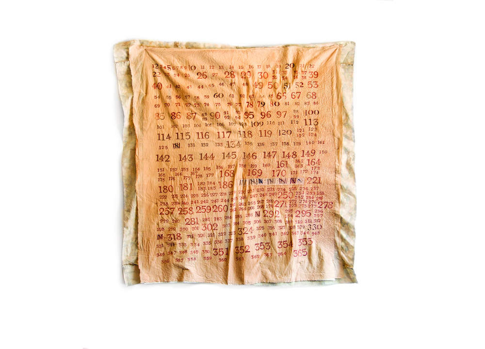
Quilt of Days

Don't Tread on Me, 1775

Signal Fire, Remarkable Hill, 22 March 1779

Nonsite, 1968

Thomas Paine, 1776

Circles, 1776

Line
While dinner was getting ready I took a walk round the Town, from the heights of which the prospect is beautiful. —George Washington, on a presidential tour of the United States in 1789
1. History is in the panorama, buried like old stones or sediment fro m an older era. But how does history reveal itself? Does it make itself known in winds and tides? In the Founding Landscape of New York City, does a summer wind blow back remembrances of the Continental Army retreating on the East River in a summer fog? Does the death tinge of fall lead a mind back to visions of the British prison ships, floating out in what is today known as Wallabout Bay, or the bodies of Continental soldiers washing up on the shores of the modern Brooklyn Navy Yard? How much mental tuning is necessary, if any, for the heat of a day to point back to the evening when troops raided a patch of summer watermelon, a scuffle ended in gunshots, a war began?
Henry David Thoreau’s first published piece was the obituary of a citizen of Concord, Massachusetts, known as the last person who remembered the events of the Revolution firsthand, Anna Jones. His last project was an almanac; he spent years collecting notations on river levels, the dates of plant bloomings, the arrival of particular bird species in Concord. In the “Economy” chapter of Walden, Thoreau ends a poem with a couplet: “The wind that blows / is all that anybody knows.”
In the winds of New York, the pages of my own mental almanac include the artists and commemorators and various reenactors of the Revolutionary War and its associated dates, all of them artists of a sort, in my mind, asking us to flatten time, or to reconsider it. In the re-creations, an event gains dimension, is reflected and refracted through various intermediary times. Each season is a kaleidoscope turned by the pages of the calendar.
In the winds of January, for instance, I look to the old records and reports to see that, in that same month in 1780, Johann Conrad Döhla, a Hessian soldier, reported the Hudson and East Rivers frozen solid, eighteen feet of ice. Likewise, I see that on January 23, 1917, editors and artists from the Masses—including John Sloan and Marcel Duchamp—climbed the staircase inside the Washington Square arch (installed in 1889 to celebrate the centennial of Washington’s inauguration) and asked President Woodrow Wilson to recognize the “Free and Independent Republic of Washington Square” in response to concerns that international finance was pushing nations toward wars over energy supplies. They drank tea, a reference to the Boston Tea Party.
As February freezes, I note the thirteenth day of that month in 1780, when, during the coldest winter in recorded US history, a wildcat was reported to have come across the frozen Hudson from New Jersey.
In March, I might remember only back to the year 2000, when the Mercer Oak died, the Mercer Oak being the tree beneath which, according to tradition, General Hugh Mercer was wounded by a bayonet during the Battle of Princeton. “Young and old remembered playing, flying kites or being read to with the Mercer Oak always a prominent part of the activity,” said an official township press release only four days after the death of Richard Baker, the town historian who had worked to preserve the tree. The president of the Princeton Township Shade Tree Commission said, “We’re losing bits of history when guys like him and the oak pass away.”
In April 1939, I see that on the spring day that George Washington was rowed to Wall Street from New Jersey, about to be inaugurated as president, Denys Wortman, an artist who studied with the so-called Ashcan school and drew cartoons for the World-Telegram, reenacted Washington’s swearing in, the United States losing an economic battle, as the world’s markets crashed. An example of a Wortman cartoon: two dejected-looking men standing on a crowded street. “They call this a ‘recession,’ not a ‘depression,’ ” one man says to the other, “but I don’t feel any difference.”
And then, as May turns to June, and, in modern times, boats from around the world typically dock in New York Harbor during so-called Fleet Week, I recall the British invasion, in 1776, when the masts of what was then the largest fleet in the world bristled against the horizon, a menace from across the seas.
And then in my mind, and in the ways of the vacation-going public, August is the month of retreat, the Americans fighting the tides from Brooklyn to Manhattan, a Delaware Crossing warm-up. From a memoir written at the time: “Unluckily, too, about nine o’clock the adverse wind and tide and pouring rain began to make the navigation of the river difficult… . [A]t eleven o’clock there was another and a favorable change in the weather. The north-east wind died away, and soon after a gentle breeze set in from the south-west, of which the sailors took quick advantage, and the passage was now direct, easy, and expeditious. The troops were pushed across as fast as possible in every variety of craft—row-boats, flat-boats, whale-boats, pettiaugers, sloops, and sail-boats—some of which were loaded to within three Inches of the water, which was ‘as smooth as glass.’ ”
And with the fall comes a procession of apple names that reach back decades and centuries: summer pippin, autumn pearmain, seek-no-further, Jersey sweet, maiden blush, Gravenstein, Newtown pippin, golden russet, Wagner, northern spy, and Roxbury russet.
A few Septembers ago, in the very first days of the month, there was a brief but terrible storm, a not untypical late summer thunderstorm that resembled the one that killed a few American soldiers in Manhattan hours after the Americans evacuated from Brooklyn in 1776. The Iconography of Manhattan Island, 1498–1909, the great twentieth-century masterwork of New York City history by I. N. Phelps Stokes, quotes from a 1776 edition of the Connecticut Gazette: “Lightning strikes Gen. McDougall’s Camp, ‘near the Bull’s Head in the Bowry,’ and instantly kills Capt. Van Wyck and his two lieutenants, Versereau and Depyster.” In 2010, meteorologists identified a tornado that came through Brooklyn, off the harbor and up toward the hill once known as Mount Prospect, now in the center of Prospect Park. There was hail and eighty-mile-an-hour, tree-destroying winds, like what Aeolus might have unleashed to attack the battle-weary Trojans. A torrential rain linked the streets and subway tunnels to the ancient creeks and streams, the topography of the pre-city. The next morning, as I looked around and walked through the wreckage, what struck me was that the tornado had followed a path identical to that taken by the British and American armies during the Battle of Brooklyn, in 1776: the strategic routes were delineated again by the winds. In the bright, scrubbed-clean air, I walked from the harbor up the hill to the site of the Battle of Brooklyn, taking the route of the American retreat. On the route and at the old battlefield, scores of old majestic trees were fallen. As foresters chainsawed, park-goers circled quietly, as if in mourning, some counting the rings on the oldest trees.
2. The word almanac may have Arabic origins, having entered into English in the twelve hundreds, or it may have roots in Hebrew. Theories pertaining to its precise origin include a relationship to words that mean measure, gift, time, and fate. An almanac carried by a traveler on the pilgrimage to Canterbury that Chaucer described would have had pages filled with tables that described the motions of the sun, moon, and planets; it was a tool for important astronomical calculations. “A table of the verray Moeuyng of the Mone from howre to howre, euery day & in euery signe, after thin Almenak,” Chaucer wrote in A Treatise on the Astrolabe: Addressed to His Son Lowys, published in 1391. The Treatise is a type of technical writing that we might today categorize as having to do with environmental science, a reason perhaps why Chaucer was so loved by Henry David Thoreau, who spent the last years of his life assembling his almanac, what scholars refer to as his Kalendar, his month-organized lists of natural phenomenon. Another reason was Chaucer’s humor—Thoreau loved a joke. “He is so natural and cheerful, compared with later poets, that we might almost regard him as a personification of spring,” wrote Thoreau.
In the fifteenth century, almanacs began to be published for particular years, and eventually for one year at a time, and by the time the American Revolution began, weather predictions had been added. People kept yearly almanacs and wrote notes in them, comparing the weather predicted with the weather that had happened, noting family milestones. Colonial almanacs contained bawdy prose (“Dick on the Hay doth tumble Nell, / Whereby her belly comes to swell!”), as well as light verse. Readers enjoyed practical philosophy (“Drive not too many Ploughs at once”) but frowned on particular politics, preferring a general lampooning of all officialdom instead (“Why should the law a cobweb be, Small Flies to catch while great go free?”). A printer might print an almanac alongside his usual run of newspapers.
By 1801, when Hugh Gaines offered an almanac for citizens of New York and its environs, it included dates of solar and lunar eclipses and astrological signs and dates of high tides, as well as the price of capers, canes, and cambric, and of hemp and hides (raw). The cycles of the moon were noted with small typographical ornaments, and particular days predicted particular atmospheric conditions with poetic brevity. January 24: “Look for snow.” February 23: “High winds.” March 28: “Now pleasant.” April 28: “Growing season.” May 2: “Smoakey air.” June 2: “Sultry hot.” July 31: “Dog days begin.” August 19: “Excessive hot.” September 7: “Dog days end.” October 30: “Cool evenings.” November 5: “North winds.” December 29: “Good slaying.” There are tables noting government officials—local and national elected representatives, judges, and customs officials, for example—but aside from those deemed saints, people are not mentioned in the almanac, with one exception. A note on the bottom of the page for February (“…hath 28 days”) says: “G. Washington was born Feb. 11, 1732, Old S. which answers to the 22nd of the present Style.”
Thus, in the American almanac, Washington is in with the weather, his birth mingled with high tides and full moons. Thomas Jefferson is president in 1801, still squabbling with John Adams, but their, say, currency-decorating-level of Founding Fatherhoods is still years away. Washington, on the other hand, despite a rocky presidency (he disliked partisanship to such an extent that he bred it) becomes a Founding Father startlingly early on—since just before he arrived in New York. He becomes Father, moreover, at the moment the nation kills off the king, when the country first begins to refer to itself as a country as opposed to a collection of colonies. Boston is where the violence of the move for independence is ratcheted up—specifically, with the Battle of Lexington and Concord, which led to the Siege of Boston. But after the British retreat to Halifax on March 17, 1776, the British fleet returns to New York City to land the largest amphibious force ever seen in New York Harbor, or, as is often noted, in the world, prior to the Allied invasion of Normandy. At this point, the war takes a dark and formal turn; the states, struggling to assemble the Continental Army, each send troops to New York. On July 9, Washington will read the Declaration of Independence in what is today City Hall Park, as battlements are completed all around the city and in Brooklyn. The Continental Army will face the British on the field of battle for the first time, and, shortly thereafter, the British will chase the limping Americans around the city and into the suburbs. It is in this way then that the New York metropolitan area becomes the Founding Landscape.
Ben Franklin and John Adams were rowed out to Staten Island from lower Manhattan for last-minute peace negotiations as the colonists clung to the fading hope that the king was not to blame, that it was his parliament attempting to take away the colonists’ rights as citizens of the British Empire. And the colonists counted almost completely on that notion right up until January 1776, when King George, in a speech, characterized the colonial rebellion as being “for the purpose of establishing an independent empire.” Then the relationship was over. “Your name darkens the moral sky and stinks in the nostrils of the world,” said a writer calling himself Soldier in a broadside against the king.
Thus commenced a kind of exchange, one father for another, both named George, the name from the Greek, meaning earth worker or farmer. A few weeks later, in what is today known as the Washington Heights section of Manhattan, Mount Washington was named in honor of the new father, followed by the name Washington showing up all over the North American map. It is thought that the first time the appellation was applied formally—the first time Washington was referred to in print as “The Father of Our Country”—was in the 1779 edition of the Lancaster Almanack.
3. Military officers in training are often taken out by more experienced officers on what are referred to as staff rides. In the preface to The Staff Ride, published in 1987 by the US Army Center of Military History, the army chief of staff wrote:
Staff rides represent a unique and persuasive method of conveying the lessons of the past to the present-day Army leadership for current application. Properly conducted, these exercises bring to life, on the very terrain where historic encounters took place, examples, applicable today as in the past, of leadership, tactics and strategy, communications, use of terrain, and, above all, the psychology of men in battle.
For a history-interested civilian, a walk might become a staff ride with its object a particular place where a person might have lived or visited or battled—a well-known person such as George Washington, say, whose life in the New York metropolitan area is marked with hundreds and hundreds of plaques. A site visit might easily return to the scene of the Battle of White Plains, in suburban Westchester, to see the apple trees that are perhaps remnants of trees described by a Connecticut soldier, starving after a day of gun smoke and blood on the hill that is today the bank of the Bronx River Parkway and notoriously deadly for modern cars. A staff ride may also, I have found, simply underscore the importance of geology and topography to the creation of a city, its history and resource management—the strategy of designing a home landscape.
Whenever I go out on a staff ride, with or without a precise military reference, I often see that large numbers of people keep returning to certain places in the landscape, again and again, for seemingly unrelated reasons. It’s as if humanity just keeps circling back and hovering in certain spots. For this reason, when winter comes to New York City, I often think of the Watchung Mountains and the expeditions into the Watchungs led in the late 1960s by the artists Robert Smithson and Nancy Holt.
The Watchungs are mountains that you might not call mountains if they hadn’t been pointed out to you. They are low, a long stretch of hills, shaped like a bracket as seen from overhead. They run from southwest to northeast, from Middle Brook, New Jersey, with a view of New York City and the harbor, to Mahwah, New Jersey, in view of the Hudson River and the Tappan Zee. The Watchungs are the bleacher seats for New York Harbor and the city, as well as for the New Jersey Meadowlands, the swampy, industry-fringed and river-crossed floor of the amphitheater created by the Watchungs. People tend to think of the Watchungs in bits (as I had for many years) and maybe know the names of isolated hills—Pill, Long, Goffle—or of individual mountains: Second Mountain, Newark Mountain, Preakness and Campgaw Mountains. I had spent about thirty years negotiating them as individual hills, even sometimes working alongside them, as a newspaper reporter in Passaic and Paterson, New Jersey, where Garret Mountain is a notable peak in the range. I saw these hills as connected when I examined George Washington’s maps—the Watchungs are a strategic ring, protecting his winter headquarters from attack by the British, who were based in Manhattan during the Revolutionary War. “Washington’s choice of winter quarters at Morristown behind those natural redouts was a stroke of genius,” wrote Bradford Willard in a 1963 essay entitled “Geology and Wars: A Neglected Factor in Wars Within the Continental Limits of the United States of America.”
My understanding also expanded in considering the work of Robert Smithson, the artist thought of as a founder of land art, a school of art that was revolutionary in the early seventies, when artists took their art out of galleries, making large sculptures in the out of doors. Smithson is best known for his Spiral Jetty, often described as a “monumental earthwork”: it is a fifteen-hundred-foot-long coil of basalt rocks and earth that opens out counterclockwise into the Great Salt Lake of Utah, installed by Smithson with the help of his wife and collaborator, Nancy Holt, and a local construction contractor. Shortly before Smithson built his first earthwork, he took a trip, in either the last few days of 1965 or in the first few days of 1966 (the history books are not clear on the precise day), as part of a writing assignment for Harper’s Baazar. It was an expedition into the Watchungs, to a peak that had become a quarry.
Smithson used rocks that he gathered in the New Jersey landscape to create some of his early sculptures in New York City galleries, predecessors of his larger earthworks, pieces he termed “non-sites.” His theories were elucidated in an essay published in Artforum in 1967, entitled “A Tour of the Monuments of Passaic.” The essay is written in the form of an account of an expedition—in this case, an expedition begun on a bus that sets out from Forty-second Street and the Port Authority Bus Terminal, and heads out through the Meadowlands of New Jersey and into the Bergen County town just across the river from the city of Passaic, a crumbling former industrial capital. In a flat tone—“I pulled the buzzer-cord and got off at the corner of Union Avenue and River Drive”—Smithson offers a tour of the sights of Passaic, the tour notable for the fact that the sites are not sites that would be on the typical tour of the day: sewer pipes, a tired and abandoned park, a mundane-seeming bridge. (The effect of some of the irony is difficult to reenact today, given that, in part due to Smithson, the appreciation of the post-industrial mundane has taken off since the seventies, a reason luxury condos have succeeded artists’ lofts in former industrial areas in many cities today.)
The artist relates the contemporary landscape to a nineteenth-century painting by Samuel F. B. Morse, entitled Allegorical Landscape. Smithson’s allegories are literal, as are his appointed “monuments,” which he photographs: the Great Pipe Monument, the Pumping Derrick Monument, and the monument of sewer pipes, the Great Fountain Monument. Then there is the bridge, one of two parallel and similarly workaday bridges: “The monument was a bridge over the Passaic River that connected Bergen County with Passaic County,” Smithson wrote. The monument-ness of the bridge then sprung from the fact that it was not a monument; there was no plaque memorializing the bridge into Passaic, and the inherent question was: why do we celebrate one thing over another?
Nine years after he made his expedition and crossed the monument that was the bridge over the Passaic River, the bridge parallel to the one Smithson crossed was more traditionally memorialized—i.e., a bridge over the Passaic River that connected Bergen County with Passaic County was actually marked as a monument, just in time for the national bicentennial celebration. It was a city-sanctioned monument, not due to Smithson, but due to George Washington. And indeed, if you look today with an eye to the past, Smithson’s expedition into downtown Passaic (“Passaic center loomed like a dull adjective,” he wrote) is lined by monuments of Continental soldier encampments and long-ago Washington activity. Smithson would likely have passed a small stone monument to a 1776 troop encampment that is today hidden in a Burger King parking lot. I had been a newspaper reporter in Passaic, which was known as Acquacknonk in 1776; it was my first job out of college, in 1985. I had traveled these same bridges on numerous occasions, and serendipitously retraced Smithson’s steps not as an art project but as a project that was about me getting lunch, or cashing my paycheck at the bank of the newspaper I worked for, or covering city council meetings across the Passaic in Bergen County, in a town called Rutherford, or another called Wallington, accidental wanderings. Several art historians have reenacted Smithson’s bus trip to Passaic, looking for his monuments that were not monuments or their vestiges. When I went back to Passaic for the first time in a long time, I noticed the new plaque on the old bridge, which I had not seen before: Acquacknonk Bridge / Gen. George Washington’s Army pursued by the British crossed over here November 21, 1776 destroying the wooden bridge behind them. Placed by the combined civic organizations of Wallington Nov. 21, 1976.
4. Robert Smithson was born in Passaic in 1938, and moved to Clifton, the neighboring town, while in high school. He was delivered by William Carlos Williams, the Smithson family doctor, who was based in Rutherford, a town bordered by the Passaic River and by the edge of the Meadowlands. Williams was the author of an epic poem entitled “Paterson,” which is structured using the Great Falls of Paterson, a Niagara-esque cataract often noted in the journals of colonial soldiers, including Alexander Hamilton. (As treasury secretary under President Washington, Hamilton spearheaded a plan to use the falls as the centerpiece of a US manufacturing economy that would help make the United States independent of Britain.) The trip from Manhattan to the quarry at a peak in the Watchung Mountains was across Smithson’s own personal Founding Landscape.
And so when I think back to that other expedition—in another sort of monumental way—I picture Smithson walking down the stairs of his loft apartment on Washington Street, in Manhattan, and driving to New Jersey with Nancy Holt, whom he often collaborated with. I see Smithson and Holt with Donald Judd, the artist who shared an interest in rock hunting with Smithson, and Judd’s then wife, Julie Finch, a dancer now also known as a preservationist. (Finch recently helped conserve the only known underground railroad site in Manhattan, in Chelsea.) Smithson, in the Harper’s Bazaar story: “Together with my wife Nancy, and Judd’s wife, Julie, we set out to explore that geological locale.” They read Sunday papers, passengers making sounds of pages turning. The car’s odometer is broken. They will end up at the Great Notch Quarry, but the first stop is on the First Watchung Mountain, near Paterson. The men chip away at the remains of a lava flow as the wives collect sticks and stones. They break for milk shakes—Awful Awfuls (“awful big and awful good”)—and go to the next quarry. “For about an hour Don and I chopped incessantly at the lump with hammer and chisel, while Nancy and Julie wandered aimlessly around the quarry picking up sticks, leaves and odd stones,” Smithson will write. “From the top of the quarry cliffs, one could see the New Jersey suburbs bordered by the New York City skyline.” Finally, I picture them seeing the city off in the distance, always, for me, an astounding sight, a museum-quality landscape painting in of itself. Forty-four years later, along the same ridge, yet another plaque was installed by the county government:
The hill on the east side of
the Notch was used by
Washington as a lookout
from which to observe the
movement of his troops.
These hills, these quarried peaks, are, I would argue, among the establishing sites of land art, and I ran into them a few years ago when I spent some time wandering the Watchungs. I was out on a staff ride, looking for viewpoints the Continental Army might have used, like the Great Notch site. At many of the viewpoints along the ridge of the Watchung Mountains, there are overlooks marked as Washington lookouts. (People that I met in the towns nearest each particular site would often describe their town’s viewpoint as the war’s most important.) There were points in the hills north of the Watchungs—at Torne Mountain, farther up the Hudson, it is said that Washington lost a watch and that the clock’s ticking can still be heard—as well as points south, to Sandy Hook, where Smithson also collected nonsite rocks. In Morristown, New Jersey, on what is technically referred to as the Fourth Watchung Mountain, there is a plaque that describes the chain of signal beacons installed at many of these sites, pyramid-shaped stacks of brush and wood, ready to be lit when British movements were spotted, to alert local militias. I also discovered that these same signal points were strategic once again during the Cold War, when the missile sites were installed on or near the old signal sites. More recently, many of the same sites have had plaques and sculptures added as memorials to the World Trade Center disaster. On September 11, 2001, communities went to the old viewpoints to witness the tragedy, and the memorials there today list local residents who died in lower Manhattan, its buildings almost shouting in the east. Meanings line up at the sites; strategies and emotions coincide at these elevated folkways, and all then look out over the New Jersey Meadowlands, the vast and swampy nonsite of the Revolution. The Meadowlands is to me the opposite of where the Delaware was crossed, or victory won at Yorktown in Virginia. In 1776, the Continental Army ran like hell through the Meadowlands, scattering in New Jersey, fleeing from the British army, following its losses in New York. Signs on the back roads of Bergen County today attempt a positive spin: “Retreat to Victory.”
In my library expeditions, I can only find one specific reference to George Washington made by Smithson. According to an essay by Thomas Crow written for the catalogue of a Robert Smithson show at the Whitney Museum of Art in 2005, Smithson mentioned (in a spiral-bound notebook full of references to spirals in various works of art and literature) an 1860 publication entitled The Washingtons: A Tale of a Country Parish in the Seventeenth Century Based on Authentic Documents, which includes a description of something called the Shepherd’s Labyrinth, a spiral cornfield maze, the particular type of which is likely to have been witnessed by the English ancestors of George Washington. I think of the Washington family maze whenever I see a six-minute color film that Smithson and Holt made together in 1969, called Swamp. (It can be seen online.) Holt, who also spent much of her childhood in New Jersey, runs her camera and walks into the reeds of the Meadowlands.
I can imagine people might find Swamp to be unmercifully boring, the stereotypical art film. I do not feel this way, but then I myself have had a long history in the Meadowlands; my wife and I used to drive around out there when we first met, a little over twenty years ago, aspiring artist and aspiring writer, only months from marriage, driving the shoreline of the swamp that is, geologically speaking, all that remains of glacial Lake Hackensack, enjoying industrial ruins. I remember taking her to see the Great Falls on an early outing, as a date; I loved exploring with a collaborator, even if we weren’t sure how we were collaborating, and as she snapped pictures, it charged the place that I had worked in and pondered for so many years with an additional grace.
The Smithson and Holt film is a version of the Shepherd’s Labyrinth from the point of view of two post-Fluxus-influenced artists: a walk into nothing more than the infinity of the swampy ground cover. But it is also, I think, a little bit of a land-based metaphor for marriage, that unexplainable collaboration between two married people. In an interview in 1971, Smithson described Swamp as being, in his words, “about deliberate obstructions or calculated aimlessness.” It seems to me that “calculated aimlessness” could also be construed as a version of love.
Smithson will die in a plane crash four years after the film is made, at the age of thirty-five, while surveying a project site in Texas, but in Swamp, the viewer hears him directing Holt, over the sound of the old 16 mm Bolex camera, the soothing white noise of film advancing. Excerpts of some of what they are heard to say on the film, which features mostly reeds and a little bit of sky:
Him: “Just walk in a straight line.”
Her: “I think I am.” (She wasn’t, exactly; she was about to circle back, as it ended up.)
Him: “Don’t worry about the focus. Just keep advancing in, as much as you can.”
Him: “Okay, make an about-face…. Go back the way you came.”
Her: “This way?”
Him: “Shoot into the density of it.”
Her: “I can’t see anything.”
Him: “It’s okay.”
Him: “Watch out, the reeds can cut a little.”
The film ends suddenly, with a misunderstanding on the part of Smithson.
Her: “How many feet left on the reel?”
Him: “Uh, hundred.”
Her: “Hundred?”
Him: “Well, it says a hundred on there.”
Her: “I think it says ten.”
At this point, the sound of the camera stops, indicating that the last length of film is passing the lens. Smithson has the last word, as the film ends with him, a deadpan remark.
Her: “What does it say?”
Him: “Nothing.”
5. I have seen the reenactment of the Crossing of the Delaware, held every year at Washingtons Crossing, Pennsylvania, and, like strict constitutional constructionists, the reenactors involved demonstrate an interest in a literal sense of the past; in looking at history—the boats from another era, the torn rags for shoes, the presumed thinking of Washington on the day he chose the password “Victory or Death”—they point a finger, draw a straight line back, to say, “There!” Smithson’s consideration of time as we see it in the landscape is an important inverse. “On this site” is an opposite of “in this vista,” as it is also an opposite of Smithson’s notion of nonsites. It is easy to see land art as initially practiced as a reaction to the commercialization of art and the gallery space: in Smithson’s Spiral Jetty, for instance, or when he poured asphalt down the edges of quarries, in Italy, in 1969, for a piece entitled Asphalt Rundown. But Smithson’s notion of the “nonsite” has also become increasingly prescient as a way of thinking about landscape in general.
Meanwhile, land art as genre comes under criticism, now just as it did when it was first practiced, for its destructive impact on the landscape. “There has been a backlash against the grandiosity and possibly destructive nature of these projects, which were under way or completed when environmental restraints were nonexistent and before the general consciousness about ecology had been raised,” wrote Ann Landi in ArtNews in 2004. More sensitive land art is, by this thinking, created by the descendants of Smithson, who seem to work with the landscape, artists such Andy Goldsworthy and Maya Lin, whose work is perceived as less overtly manipulative of the land, and, thus, in the jargon of environmentalism, more ecologically sustainable. Goldsworthy’s work, in his words, “looks into the heart of nature.”
But calling land art destructive and ignorant of ecology is a radically literal critique. While it is true that environmental regulations were not as stringent in the seventies as they are now (or as they are at the moment, at least), these modern regulations were in fact coming into place as land art was born. In 1968, a show entitled “Land Art” opened at the Dwan Gallery, featuring Smithson and Walter De Maria, among others, while the Clean Water Act was introduced by President Nixon in 1972. Complicating matters further is the argument made today by many ecologists that the landscape must be shaped or reshaped (or managed, as restoration ecologists put it), that a healthy ecology requires that we do so. Salt-marsh ecologists who cited sinking coastal wetlands as a threat to the city of New Orleans before Hurricane Katrina were proven correct, unfortunately; cities are recently investigating the addition of sediments to coastal marshes, which, more research shows, revives the indigenous salt-marsh ecology, decreasing coastal flooding as well as propagating suites of wetland species. It is not only a shock to the thinking of many conservationists, but to the law: wetlands legislation that is key to the Clean Water Act has long forbidden any kind of fill in floodplains.
Smithson addressed the idea of the pristine when he faced similar criticism from a New York Times critic who argued that land artists “cut and gouge the land like Army engineers.” The Times wanted an artist to “make these places visible—communicate their spirit.” Smithson, in what would be one of the last things he wrote before he died, responded: “There is no going back to paradise or nineteenth-century landscape…” Smithson’s position might seem imperious, but in fact the idea of restoring a watershed to a previous ecological state implies a kind of ecological mastery that ultimately eludes us. Our default attitude toward land leans toward arrogance, whether we are “saving” it or using it as a resource, which is why we ultimately require the artist’s assistance in the landscape: to see the widest possible view, and to see it though a prism of humility, in which we are less masters than subjects, especially when it comes to time.
Time was ultimately Smithson’s subject. Ecological awareness is less like restoring a Hudson River school painting and more like being alert to the path of asphalt as it is poured out of a dump truck, as Smithson did in Italy, in 1972: as the lavalike blackness moved down the wall of the Roman quarry, its expanding, globular tentacles hardened to create “entropy revealed.” Change drives the physical world. A piece like the Spiral Jetty is a marker in the stream of time, a viewpoint at water level. Thoreau (who, it should be noted, was under the influence of Emerson’s “Circles” when he wrote Walden) began his “experiment” on the Fourth of July, 1845. (“What is it [to] be born free and equal and not to live?”) In Walden, he writes of visiting trees not for the sake of the tree, but as a reference point, just as his cabin was a reference point for the revolution of seasons, a viewing platform. “I paid many a visit to particular trees, of kinds which are rare in this neighborhood, standing far away in the middle of some pasture, or in the depths of a wood or swamp, or on a hilltop…” Thoreau wrote. “These were the shrines I visited both summer and winter.” Nancy Holt’s Sun Tunnels, a land art project in the Great Basin Desert of Utah, consists of four eighteen-foot-long concrete cylinders, big enough for a person to walk through, the openings aligned to sunrise, sunset, and solstices, the ceilings drilled with holes that, with the sun’s light, draw the pattern of constellations on the floor of the tunnels, the day and night and the earth and sky inverted. These desert tunnels are faraway shrines to other revolutions.
6. It has been argued that America’s war for independence marked a shift in colonial society, roughly put, from circles to lines. In other words, prior to the Revolution, colonial life was arranged with respect to circular, or more specifically, cyclical markers—tides, lunar cycles, seasons, and the movement of the sun. People farmed, traveled, conceived children, and—according to an essay entitled “Circles and Lines” by the historian John Demos, died according to these cycles. Atmospheric disturbances were interruptions to the cycle, and thus omens. A comet that appeared at the time of the Boston Massacre was widely considered a good omen, for instance, a sign of colonial fortunes improving. It quickly became associated with the colonists’ cause. Lexell’s comet, as it is known, could be seen by the naked eye in America, coming within 1.4 million miles of earth, the closet comet ever, and, in a sense, Lexell’s comet is the father of the American flag’s stars, arranged amongst the stripes as a “new constellation.” (The Boston Post Boy first mentioned a star and a flag in 1774: “The American Ensign now sparkles a Star.”)
A conception of life as more linear settled in after the Revolution, as devices such as the clock and the time card more and more replaced the sun, as the railroad set the country to schedules, as telegraphs ran along lines, literally, to bring news at any time of day. Lately, in addition to reading old almanacs, I have been reading the journals of people alive before and after the Revolution, looking for that shift from circle to line, and watching especially for mentions of schedules or moons. Not too long ago, I read about Mary Fish, who lived from 1736 to 1818, her life documented in The Way of Duty: A Woman and Her Family in Revolutionary America, written by Joy Day Buel and Richard Buel Jr. Mary Fish survived three husbands, and for her a good marriage seemed to be a combination of circle and line, a sine curve that went through deaths and sad illnesses and, in her words, “thankfulness while I had it.” In Fish’s life is a story that seems to me to show a point at which the circles (the moon) and lines (a schedule) contrasted. It’s a nonsite in American society’s time. In March 1805, Fish saw her son off on a boat to England, and shortly after the ship left, word arrived that another ship coming from England had sailed into a field of icebergs and sunk. Two months later another letter came, saying the England-bound ship had made it safely across: the same field of icebergs had been successfully navigated under a full moon. “What do you cry for?” Mary Fish was asked by John Dickinson, her third husband, when the letter arrived. “For joy sir,” she said.